
Trails Overview
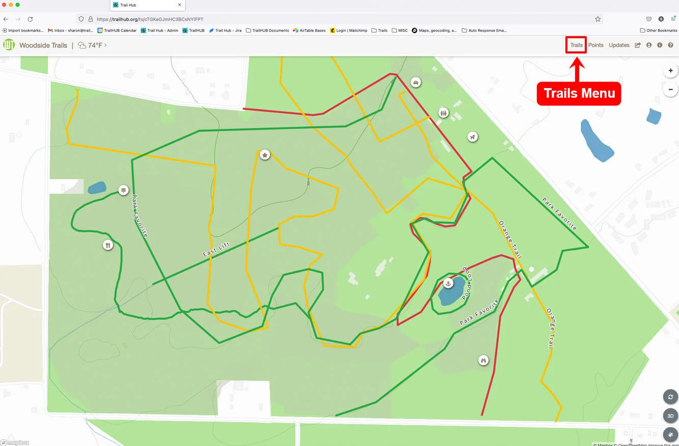
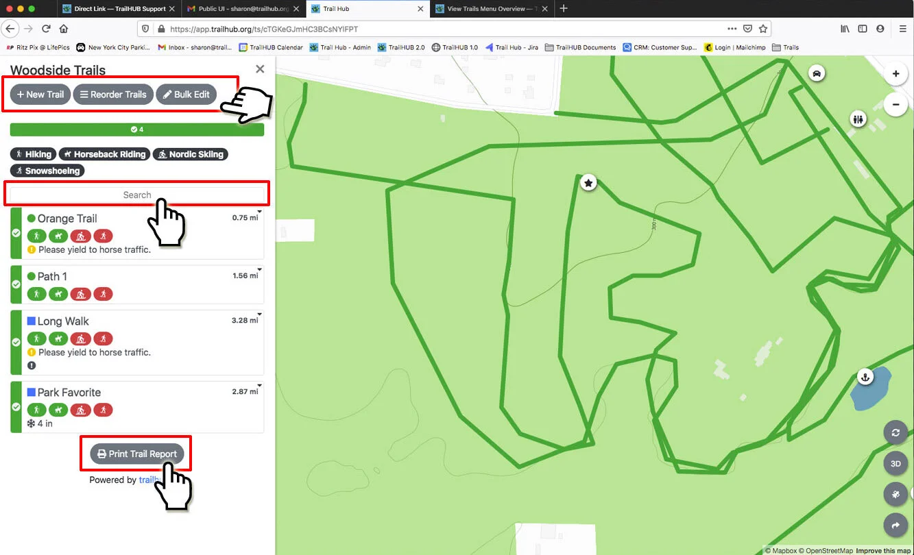
The Trails menu lists every trail in your trail system and is where you create, map, edit, reorder, bulk edit, and report on trails.
The Trails menu is where you view and manage all the trails in your trail system. Each trail card shows the trail's status, difficulty, activities (each with its own status), distance, and any current updates (notices, snow report, surface conditions).
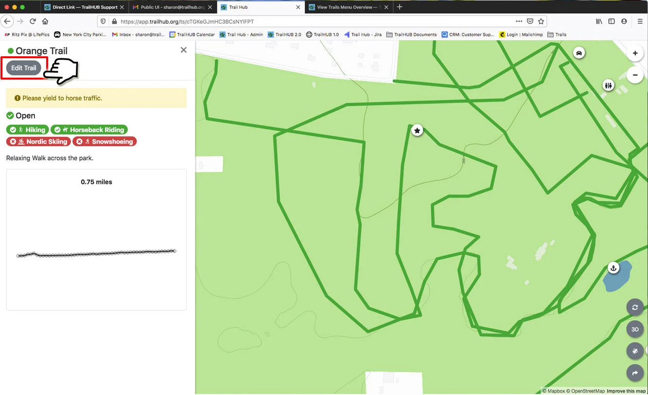
Click a trail card to open the trail's detail drawer with its description, status, activities, distance, and elevation profile. From there, managers can click Edit Trail.
#Mapping a trail
A trail's distance and elevation profile only appear once the trail has been mapped. There are two ways to map a trail:
- Upload a trail file (.gpx, .kml, .kmz, .geojson, or a zipped shapefile) to a new or existing trail. If you need to record files in the field, see Create GPS files in the field.
- Draw the trail directly on the map with the line tool.
#What you can do from the Trails menu
- Create a trail
- Upload one file containing many trails
- View and search trails
- Edit trails and statuses
- Bulk edit trails
- Reorder the trail list
- Print a trail report
- Download the whole trail system as a KML file for offline mapping apps
#Trail statuses explained
Every trail has an overall status, and every activity on a trail has its own status. The overall status is what colors the trail on the map, the left edge of the trail card, and the Open / Caution / Closed totals at the top of the list.
| Status | Meaning |
|---|---|
| Open | The trail is open. Shown in green. |
| Caution | The trail is open but visitors should take care. Shown in yellow. |
| Closed | The trail is closed. Saving a trail as Closed also sets every activity on that trail to Closed. Shown in red. |
| None | The trail has no status of its own; its status is inferred from its activities. |
When a trail is set to None, the trail system totals treat it as:
- Open if at least one activity is Open,
- Caution if no activity is Open but at least one is Caution,
- Closed if no activity is Open or Caution (or the trail has no activities).
Use None for trails shared by several activities with different statuses (for example, open for hiking but closed for mountain biking). The trail card then shows only the activity badges, without a single overall status.
Lifts and hidden trails are excluded from the trail system totals and from the activity totals.
#Trail fields
| Field | Options | Notes |
|---|---|---|
| Name | Text | Required. |
| Type | Standard, Lift | Lifts have no difficulty or activities, draw as a dashed line, and do not appear in the trail list. See Lifts and wait times. |
| Status | Open, Caution, Closed, None | See above. |
| Description | Text | Shown on the trail detail drawer. |
| Categories | Your trail system's categories | Only shown if you have set up categories. |
| Difficulty | Beginner (green circle), Intermediate (blue square), Expert (black diamond), Expert Only (double black diamond), Terrain Park, Not Rated | Not shown for lifts. |
| Activities | Any from the activity list, each with its own Status (Open / Caution / Closed) and Difficulty | Trails are listed under each activity you add. Activities are ordered by status when the trail is viewed. |
| Import Trail File | .gpx, .kml, .kmz, .geojson, .zip (shapefile) | Or draw on the map instead. |
| Line Style | Solid, Dashed | How the trail renders on the map. |
| One Way | On / off, plus Reverse Direction | Adds direction arrows along the trail and a one-way badge on the card. |
| Trail Hidden | On / off | Hides the trail from public view. Managers still see it, labeled "(Hidden)". |
Available activities: ATV Off Road, Biking, Climbing, Disc Golf, E-Bike, Fat Biking, Fishing, Fly Fishing, Hiking, Horseback Riding, Lift Access Biking, Mountain Biking, Mountain Biking - Adaptive, Nordic Skiing, Nordic Skiing - Skating, Nordic Skiing - Alpine Touring, Nordic Skiing - Backcountry, Nordic Skiing - Single Track, Paddling, Recreational Paths, Rollerskiing, Skiing/Snowboarding, Skating, Snowmobiling, Snowshoeing, Trail Running, Winter Walk, Zipline.
#In this section
- Create a Trail
Add a new trail to your trail list and map, including its status, difficulty, activities, and geometry.
- Draw or Edit a Trail on the Map
Use the map's line tool to draw a new trail or adjust the geometry of an existing one.
- Upload a Trail File
Map a new or existing trail by importing a GPX, KML, KMZ, GeoJSON, or zipped shapefile.
- Upload One File with Many Trails
Bulk import a trail system from a single GIS file containing multiple line features.
- Create GPS Files in the Field
Record each trail with a GPS tracking app such as Gaia GPS and export it as a GPX or KML file to upload to TrailHUB.
- View and Search Trails
Browse the trail list, filter it by activity or status, search by name, and download your trail system as a KML file.
- Edit Trails and Statuses
Update a single trail's details, status, activities, and map line, or delete it.
- Bulk Edit Trails
Change the status, difficulty, activities, categories, or hidden setting of many trails in one operation.
- Reorder the Trail List
Sort the trail list alphabetically or by difficulty, group it by activity, or drag trails into a custom order.
- Trail Reports
Generate a printable PDF of your trail list, optionally filtered by activity or status.